Written by Navimatics Corporation
Get a Compatible APK for PC
| Download | Developer | Rating | Score | Current version | Adult Ranking |
|---|---|---|---|---|---|
| Check for APK → | Navimatics Corporation | 17 | 2.11764 | 5.4.15229 | 4+ |

What is Charts & Tides?
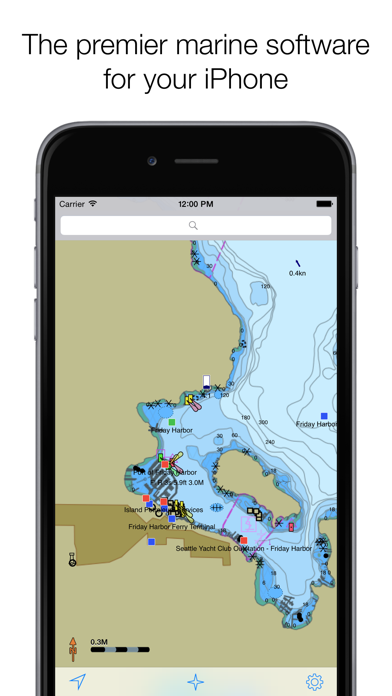
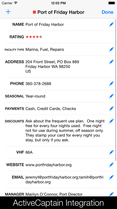
Charts&Tides is a marine app for iOS7 that provides access to charts, tides, ActiveCaptain information, GPS navigation, and more. The app is designed to be used both at home for trip planning and on the boat for navigation. The interface is intuitive and tasks have been streamlined for ease of use. The app provides continuous and seamless large area charts derived from NOAA and CHS vector cartography. It also integrates with the ActiveCaptain interactive cruising guidebook, providing access to thousands of marinas, anchorages, hazards, and other local knowledge.
1. Unlike other marine software, you do not need to download, store and manage individual charts or load them into the software; we have done the legwork for you and compiled large area charts that combine information from multiple sources.
2. The all new Charts&Tides for iOS7 is finally here! Now get access to charts, tides, ActiveCaptain information, GPS navigation and more in a well designed package.
3. The software comes with a world base map, but does not come prepackaged with any detailed marine charts.
4. - Integrates with the ActiveCaptain interactive cruising guidebook providing you with access to thousands of marinas, anchorages, hazards and other local knowledge.
5. - Provides continuous and seamless large area charts derived from NOAA and CHS vector cartography.
6. - Allows you to instantly search thousands of chart features and the ActiveCaptain database.
7. You can purchase detailed marine charts from within the application.
8. You can also use the software without purchasing additional charts.
9. - Supports waypoints, routes, tracks and allows you to import and export them in GPX format.
10. - Stores the entire ActiveCaptain database offline so that it is always available to you, even without an Internet connection.
11. - Supports external AIS devices and performs Closest Point of Approach (CPA) computations.
12. Liked Charts & Tides? here are 5 Navigation apps like AyeTides; Tides Planner; Tide Graph HD; Real Tides & Currents Graph HD; NZ Tides;
| SN | App | Download | Review | Maker |
|---|---|---|---|---|
| 1 |  i-Boating: GPS Nautical / Marine Charts - offline sea, lake river navigation maps for fishing, sailing, boating, yachting, diving & cruising
|
Download | 4/5 200 Reviews 4
|
Bist LLC |
| 2 |  Grapholite - Diagrams, Flow Charts and Floor Plans Designer
|
Download | 4.1/5 178 Reviews 4.1
|
Aphalina |
| 3 |  Spoticharts | Spotify Music Charts
|
Download | 4/5 152 Reviews 4
|
Prispiii |
Not satisfied? Check for compatible PC Apps or Alternatives
| App | Download | Rating | Maker |
|---|---|---|---|
 charts tides charts tides |
Get App or Alternatives | 17 Reviews 2.11764 |
Navimatics Corporation |
Select Windows version:
Download and install the Charts & Tides app on your Windows 10,8,7 or Mac in 4 simple steps below:
To get Charts & Tides on Windows 11, check if there's a native Charts & Tides Windows app here » ». If none, follow the steps below:
| Minimum requirements | Recommended |
|---|---|
|
|
Charts & Tides On iTunes
| Download | Developer | Rating | Score | Current version | Adult Ranking |
|---|---|---|---|---|---|
| Free On iTunes | Navimatics Corporation | 17 | 2.11764 | 5.4.15229 | 4+ |
Download on Android: Download Android
- Provides continuous and seamless large area charts derived from NOAA and CHS vector cartography.
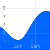
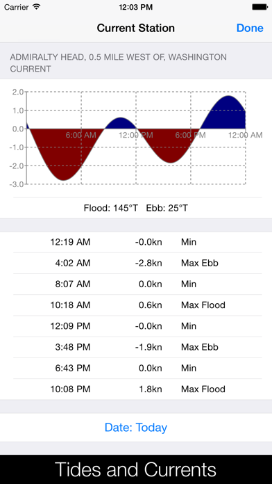
- Shows tide levels and current speeds on the chart using easily interpreted icons.
- Integrates with the ActiveCaptain interactive cruising guidebook providing access to thousands of marinas, anchorages, hazards, and other local knowledge.
- Stores the entire ActiveCaptain database offline so that it is always available, even without an Internet connection.
- Allows instant searching of thousands of chart features and the ActiveCaptain database.
- Supports waypoints, routes, tracks, and allows importing and exporting in GPX format. Route navigation with automatic waypoint sequencing is also supported.
- Supports multiple options for navigation, including using the device's built-in GPS, connecting to an external GPS via Bluetooth or Wi-Fi, and dead reckoning mode.
- Supports external AIS devices and performs Closest Point of Approach (CPA) computations.
- Comes with a dark UI that looks good during the day and preserves night vision when it is dark.
- The software comes with a world base map, but does not come prepackaged with any detailed marine charts. Detailed marine charts can be purchased from within the application. The software can also be used without purchasing additional charts.
- The app has a feature called Active Captain that was useful when it was working.
- The app baits users into purchasing expensive charts.
- The app is not compatible with iOS 11 and the developer is unresponsive to user inquiries.
- The app has stopped upgrading and supporting, but still sells to users.
- Users have reported difficulty restoring purchased charts and receiving no response from support.
- The app is not functional and requires users to purchase charts again.
Charts and Tides US East
Do Not Buy this App
Complete Rip-off
Chart Bait
 PC Apps