Written by GEC s.r.l.
Get a Compatible APK for PC
| Download | Developer | Rating | Score | Current version | Adult Ranking |
|---|---|---|---|---|---|
| Check for APK → | GEC s.r.l. | 9582 | 4.71582 | 37.6 | 4+ |
What is Aqua Map Boating?
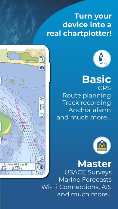
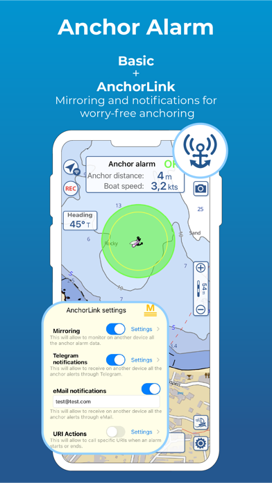
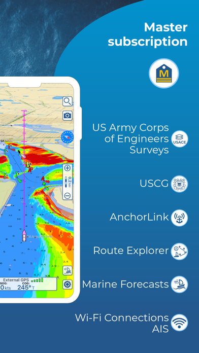
The Aqua Map app is designed to cater to all the needs of fishing and boating enthusiasts. It offers up-to-date nautical charts that can be downloaded for offline use, real-time information for planning and navigating routes and tracks, anchor alarm with advanced configuration, tide and current predictions, and simulations. The app also provides access to marine forecasts, weather buoys, and AIS info from external devices. It supports live sharing, community integration, and multi-screen mode. The Aqua Map Master feature allows users to connect their NMEA devices through WiFi and display AIS targets on the map with automatic collision detection.
1. Consult the Route Explorer with anchorages, bridges, hazards, marinas and best fuel prices (now available also for tracks).
2. Join the community of more than 100.000 boaters who write reviews, update data and provide up to date hazard information.
3. Enable the exchange of your data with the Aqua Map community and follow your favorite users on the screen.
4. Aqua Map uses only official Nautical charts with depth contours, buoys, lights, etc.
5. Navigate your route and your track (NEW) to monitor distance, time (ETA) and direction toward your next waypoint or your final destination.
6. You can share your favorite's markers on Facebook or send an email with your last daily track.
7. Download the best up-to-date Nautical Charts to safely enjoy the new boating season.
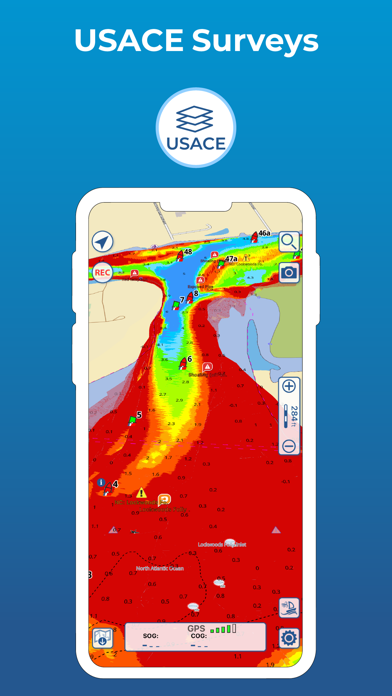
8. Display the last USACE surveys and the last USCG List of Lights (only US).
9. Marinas, hazards, anchorages, bridges, free docks and much more to cover the entire US coastline.
10. Access the last marine forecasts (wind, waves, currents and weather).
11. An app to satisfy all your Fishing and Boating's needs, developed with the help of expert boaters.
12. Liked Aqua Map Boating? here are 5 Navigation apps like Wheelmap; Trucker Path: Truck GPS & Maps; Argentina Map; New York Subway MTA Map; Droppath Route Planner & Map;
| SN | App | Download | Review | Maker |
|---|---|---|---|---|
| 1 |  Aqua TV
|
Download | 2.9/5 38 Reviews 2.9
|
Extra Mile Studios Ltd |
Not satisfied? Check for compatible PC Apps or Alternatives
| App | Download | Rating | Maker |
|---|---|---|---|
 aqua map boating aqua map boating |
Get App or Alternatives | 9582 Reviews 4.71582 |
GEC s.r.l. |
Select Windows version:
Download and install the Aqua Map Boating app on your Windows 10,8,7 or Mac in 4 simple steps below:
To get Aqua Map Boating on Windows 11, check if there's a native Aqua Map Boating Windows app here » ». If none, follow the steps below:
| Minimum requirements | Recommended |
|---|---|
|
|
Aqua Map Boating On iTunes
| Download | Developer | Rating | Score | Current version | Adult Ranking |
|---|---|---|---|---|---|
| Free On iTunes | GEC s.r.l. | 9582 | 4.71582 | 37.6 | 4+ |
Download on Android: Download Android
- Optimized for both iPhone and iPad
- Download charts on the device for offline use
- Plan and navigate routes and tracks with real-time information
- Anchor alarm with advanced configuration
- Tide and current predictions and simulations (North America and Australia)
- Overlay USACE surveys and USCG List of Lights on charts (only US)
- Access last marine forecasts (wind, waves, currents, and weather)
- Access more than 1800 weather buoys for real-time weather conditions
- Share and load tracks, markers, and routes (KMZ and GPX)
- Connect to friends using live sharing function
- ActiveCaptain and Waterway Guide community integration
- Connect NMEA devices through WiFi
- Display AIS info from external devices with automatic collision detection
- Powerful search with advanced settings
- Overlay satellite images on the map
- Fully support light/dark aspect
- Measure distances on the map
- Check all bridges, hazards, and best fuel prices along the route
- Works perfectly in iPad multi-screen mode
- Optimized battery usage
- Aqua Map uses only official nautical charts with depth contours, buoys, lights, etc.
- Calculate prediction for more than 7500 stations in US, Canada, Bahamas, and Australia
- Share favorite markers on Facebook or send an email with last daily track
- Load any KML, KMZ, GPX (also zipped) found on the internet or received from friends
- Enable exchange of data with Aqua Map community and follow favorite users on the screen
- See all active users around and chat with them
- Aqua Map Master feature provides access to last marine forecasts, NMEA devices, AIS targets, USACE surveys, USCG List of Lights, and Route Explorer with anchorages, bridges, hazards, marinas, and best fuel prices
- Type of purchases: unlimited or subscription (auto-renewable)
- Accurate in marking hazards and channel markers
- Helps keep in the main channel
- Provides offline access to Active Captain data
- Good for suggested routes and locations of services
- Provides along route info on bridges, fuel stops, etc.
- USACE sonar survey overlay is an amazing tool
- Screens are slow to load
- Limited access to Active Captain data (cannot create new POI's or add reviews)
- Explorer charts have limited detail and are Raster scans instead of Vector
- App interface is not intuitive
- Charts continue to disappear from devices despite ensuring the button in settings is off for delete charts in case of low available space
- Unreliable in its current state
Great for Navigating the Hudson
Disappearing charts, but great features
Active Captain Included
OK not great
 PC Apps